
Hi there! I am a master’s student at LIESMARS, Wuhan University ![]() , under the supervision of Prof. Zhen Dong, Prof. Bisheng Yang, Assistant Prof. Yuan Liu and Research Assistant Prof. Haiping Wang from HKUST
, under the supervision of Prof. Zhen Dong, Prof. Bisheng Yang, Assistant Prof. Yuan Liu and Research Assistant Prof. Haiping Wang from HKUST ![]() .
.
My current research focuses on 3D computer vision, with a particular emphasis on 3D scene understanding, 3D reconstruction, and 3D large language models (LLMs).
I am a member of WHU-USI3DV, please check advancements on point cloud processing including enhancement, registration, localization, segmentation, detection, etc.
🔥 News
- 2026.07: 🎉🎉🎉 Paper LEGO: Leveled Language Gaussian Splatting is accepted by ECCV 2026!
- 2025.11: 🍾🍾🍾 Paper GAGS: Granularity-Aware 3D Feature Distillation for Gaussian Splatting is accepted by AAAI 2026!
- 2025.10: 🥳🥳🥳 Paper The neural city: A next-generation spatio-temporal intelligence paradigm for urban holistic governance is accepted by The Innovation(IF:25.7)!
📝 Publications
LEGO: Leveled Language Gaussian Splatting
Yuning Peng, Haiping Wang, Yuan Liu, Yipeng Lu, Zhen Dong, Bisheng Yang
3D segmentation & Open-vocabulary Understanding
We introduce LEGO for advanced open-vocabulary scene understanding. Beyond basic concept recognition, its core innovation lies in capturing the intrinsic semantic hierarchies within the scene.
GAGS: Granularity-Aware 3D Feature Distillation for Gaussian Splatting
Yuning Peng*, Haiping Wang*, Yuan Liu, Chenglu Wen, Zhen Dong, Bisheng Yang
3D Open-vocabulary Understanding
We propose GAGS, a framework that distills 2D CLIP features into 3D Gaussian splatting, enabling open-vocabulary queries for renderings on arbitrary viewpoints.
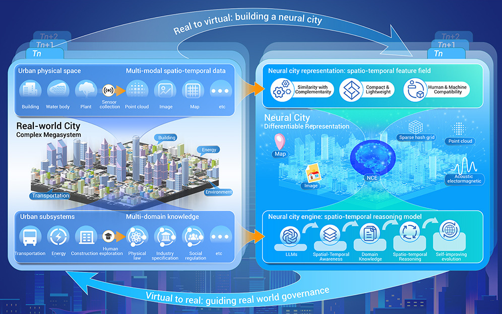
The Neural City: A Next-generation Spatio-Temporal Intelligence Paradigm for Urban Holistic Governance
Zhen Dong, Haiping Wang, Zhe Chen, Chen Long, Yuning Peng, Yuan Liu, Fuxun Liang, Jian Zhou, Yiping Chen, Fan Zhang, Bisheng Yang†, Deren Li
Spatial Intelligence System
We outline Neural City to enable end-to-end urban governance, seamlessly linking raw urban data to holistic urban governance, achieving “6W+4R” governance.
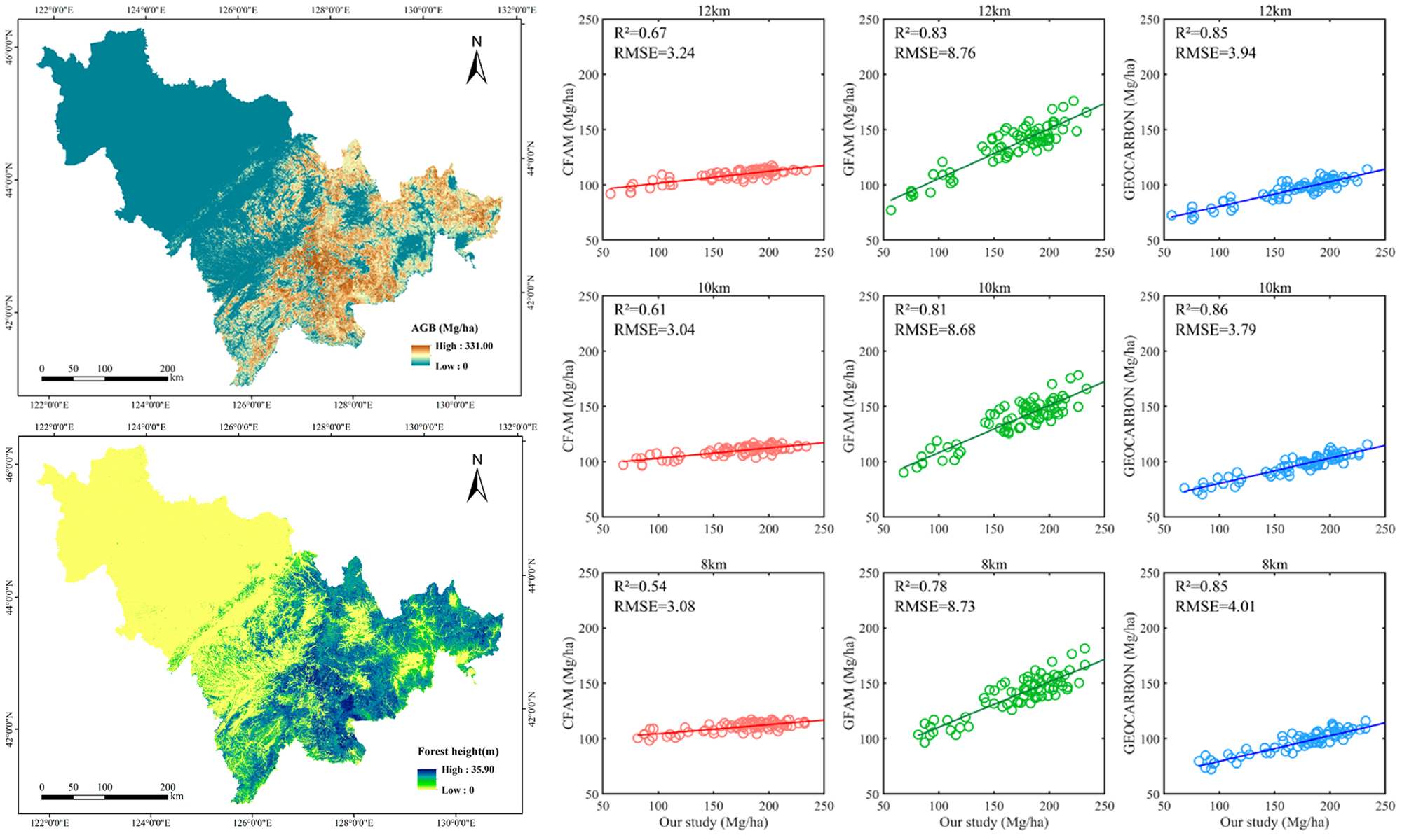
Fine-Resolution Forest Height Estimation by Integrating ICESat-2 and Landsat 8 OLI Data with a Spatial Downscaling Method for Aboveground Biomass Quantification
Yingxuan Wang*, Yuning Peng*, Xudong Hu, Penglin Zhang
Remote Sensing Spatial Analysis
We propose a novel down-scaling method to map forest height and biomass at a 15-m resolution by integrating Landsat 8 OLI and Ice, Cloud and Land Elevation Satellite-2 (ICESat-2) LiDAR data.
🏅 Honors and Awards
- 2025.10 Excellent Academic Performance Scholarship of Wuhan University
- 2025.10 Excellence Award for Graduate Students of Wuhan University
- 2023.10 National Scholarship for Undergraduates (Top 3%)
- 2023.04 Innova Student Innovation Achievement Award of Wuhan University
- 2022.08 First Prize of “China Software Cup” College Student Software Design Competition (Rank 1)
📖 Educations
- 2024.09 - now, M.S. in Photogrammetry and Remote Sensing, Wuhan University.
- 2020.09 - 2024.06, B.S., Wuhan University.
💻 Internships
- 2026.05 - now, Bytedance
 , China.